


 24/7 Emergency Service
Accuracy of Hurricane Forecasting
7/1/2019 (Permalink)
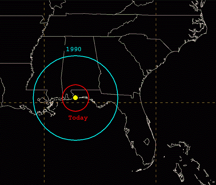 A representation of the average NHC 48-hour track errors for the forecast of a storm centered over Pensacola, Florida, in 1990 (blue) and today (red).
Our area was one of if not the hardest hit areas in the region during Hurricane Florence in September of 2018. When forecasters originally released the path of the monster storm, Florence was expected to make landfall as a Category 4 storm. However, over the coming days the National Hurricane Center (NHC) would downgrade her to a Category 1 as she made landfall just south of Wrightsville Beach on September 14 with sustained winds of 90mph. The states of North Carolina and South Carolina had already declared states of emergency and ordered many mandatory evacuations. When the storm hovered over the area and dumped nearly 40 inches of rain it became the wettest tropical cyclone recorded in the Carolinas and the eighth wettest overall in the contiguous United States (KTVQ Billings News/NHC Report May 4, 2019). Despite Florence’s weakened status of Category 1, the high pressure ridge that stalled the storm out over our state for the following days caused the major inland rivers-Neuse, Eno, Cape Fear and Lumber to breach their banks and flood the surrounding areas. The majority of Pender County and the city of Wilmington were entirely cutoff from the mainland and left many communities without food and gas for multiple days. At least 54 deaths were attributed to the storm. Many were left wondering after such a catastrophe, how accurate are the forecasts that we are given prior to a storm making landfall?
The National Hurricane Center is a component of the National Centers for Environmental Prediction which is located at Florida International University in Miami Florida. The first hurricane warning services began in the 1870’s in Cuba. As technology changed and the ability to track the storms became more accessible, the government began to invest more money and time into forecasting the deadly storms. The NHC began formally in the 1950’s using aircraft to study tropical cyclones and to carry out experiments on mature hurricanes. In 1956 a National Hurricane Information Center was established in Miami Florida. In the last 60+ years it has changed locations and the name has shifted slightly, but the main goal has remained “to save lives, mitigate property loss, and improve economic efficiency by issuing the best watches, warnings, forecasts, and analyses of hazardous tropical weather and by increasing understanding of these hazards.” (https://www.nhc.noaa.gov/aboutintro.shtml)
The first known recorded forecast was in 1954, with 24 hour predictions of a tropical cyclone’s track were made. (https://noaanhc.wordpress.com/) In the following years, the NHC has broadened the window with which the forecast is made in by releasing a hurricane season forecast for the season in May of each year. With the research assistance of NOAA (National Oceanic and Atmospheric Administration), part of whose mission is to understand and predict changes in climate and weather, the NHC can issue an outlook with 70% confidence that hurricane activity will fall within predicted ranges and that they are accurate 70% of the time. The preseason outlook is determined as close to the beginning of Hurricane Season as possible, June 1, to ensure that it accurately accounts for changes in major climate phenomenon’s such as El Nino/La Nina cycle, Atlantic sea surface temperatures and the West African monsoons-which was the origin of Hurricane Florence. (https://www.noaa.gov/stories.creating-atlantic-hurricane-season-outlook-may-makes-all-difference)
So, are the forecasts more accurate?
According to the NHC, there has been a steady reduction in the track errors over time, with average errors in the current decade about 30-40% smaller than they were in the 2000’s and about half of the size or less than they were in the 1990’s. (https://noaanhc.wordpress.com/) Obviously, the main reason the tracks are more accurate is technology, more specifically the satellites and the drones that are able to fly into the eye of the storm to observe the behaviors. Additionally the amount and quality of data available to input in the various model systems help paint an initial picture of the atmosphere and have increased dramatically in the last 20 to 30 years. These factors along with many other advancements in technology have made vast improvements in what scientists and meteorologists are able to predict.
For now we can expect that the errors will continue to decrease, but at some point the predictions will plateau. For now though, be sure that you have some kind of notification system on your phone or at your home to keep you and your family safe in the likelihood of any weather event.